
A roundup of recent products in the GNSS and inertial positioning industry from the October 2021 issue of GPS World magazine.
MOBILE
Smartwatch
Provides dual-frequency and topo maps
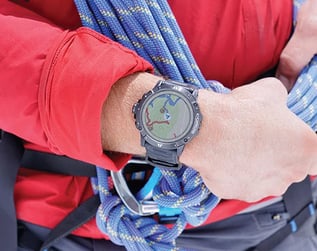
The Vertix 2 GPS “adventure watch” is equipped with a dual-frequency GNSS chipset for high accuracy. It communicates with all global navigation satellite systems simultaneously, and has a battery life of 140 hours while using GPS — otherwise, the battery extends to 60 days. Global offline maps include landscape, topography and hybrid views. The watch includes an Insta360 action camera and has 32 GB of internal storage.
Photo: Coros
Coros, Coros.com
Asset Tracking Platform
Tags, locates and monitors assets
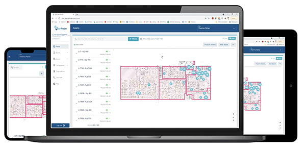
AirFinder helps companies locate, monitor and manage business assets indoors and outdoors. The quickly deployable, massively scalable platform does not require an IT infrastructure or extra components or hardware. Rather than using an internal Wi-Fi system, AirFinder operates on Link Labs’ patented and secure Symphony Link network. Location data from each AirFinder device securely flows to the AirFinder web app or directly to customer databases via extensible APIs, which enable users to monitor assets in real time, analyze asset history, add rules and alerts, establish geofences and more.
Photo: Link Labs
Link Labs, link-labs.com
OEM
Network Timing Platform
Provides boundary clock functionality at the edge
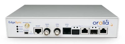
The EdgeSync network timing platform provides NTP and PTP grandmaster and boundary clock functionality for real-time edge applications. High performance, scalability, ease of use and manageability make EdgeSync suitable for data centers, finance, mobile edge computing, enterprise, smart grid, industrial IoT, process control and telecommunications. EdgeSync uses a multi-GNSS receiver (GPS, Galileo, GLONASS, BeiDou and QZSS), PTP and Synchronous Ethernet (SyncE) as input references and generates PTP, SyncE, NTP and timing signals (10 MHz, 1 PPS and time-of-day message) as outputs. It features dual 1-GbE ports for both copper RJ45 and optical network timing connections. EdgeSync also can provide IEEE 1588-2008 (PTP) grandmaster and boundary clock functionality.
Photo: Orolia
Orolia, orolia.com
Hardened Compass
Real-time MIL-SPEC location and direction

CompassOne provides real-time military-grade location, orientation and direction sensing for deployed static and on-the-go assets. It receives all GNSS, ensuring uninterrupted operation. The device can be used both in counter UAV operations and general situations requiring satellite navigation. With a strong focus on durability and ruggedness, CompassOne is suitable for installation and operation in harsh environments. Military-grade connectors and high-end stainless-steel hardware ensure uninterrupted connection and protection from the elements, while the aluminum underside provides exceptional impact resistance and rigidity while keeping overall weight low. CompassOne can operate alone or be integrated with DroneShield’s DroneSentry system.
Photo: DroneShield
DroneShield, droneshield.com
5G Platform
Provides dual frequency to consumer smartphones

The Snapdragon 888+ 5G mobile platform is expected to power commercial smartphones from ASUS, Honor, Motorola, vivo and Xiaomi in the second half of this year. Satellite systems supported include all four constellations (GPS, BeiDou, Galileo, GLONASS) with dual-frequency GNSS. Additional systems supported include NavIC, QZSS and SBAS. Snapdragon 888+ provides AI-enhanced gameplay, streaming, photography and premium connectivity. Compared to its predecessor (the 888), Snapdragon 888+ provides an increased Qualcomm Kryo 680 CPU Prime core clock speed at up to 3.0 GHz and the sixth-generation Qualcomm AI engine with up to 32 TOPS AI performance, an improvement of more than 20%.
Photo: Qualcomm
Qualcomm Technologies,qualcomm.com
Software-Defined Simulation
Supports latency of 5 milliseconds
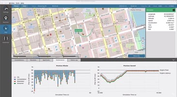
A new real-time performance capability, now standard on all Skydel-powered GNSS simulators, achieves an ultra-low latency of 5 milliseconds. Skydel’s software-defined architecture is designed to meet the demanding GNSS simulation testing requirements in the automotive, military, space and other high-tech industries. Skydel also supports hardware-in-the-loop simulations without sacrificing ultra-low latency and high-end performance. A dashboard shows real-time performance graphs and enables users to grade the simulator’s performance, interpret data, diagnose inefficiencies, and optimize scenarios on the fly. As the system reaches its limits, it remains stable and fully operational, preserving the integrity of the simulation.
The Skydel Real-Time Performance graphs illustrate the software-defined engine’s low latency during a GNSS simulation. (Screenshot: Orolia)
Orolia, orolia.com
SURVEYING & MAPPING
Utility Locator
Software with GNSS receiver enables mapping
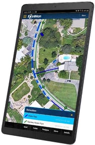
PointMan software is now integrated into the Vivax Metrotech vLoc3 with a GNSS real-time kinematic (RTK) receiver to create a utility-locate device. Using the RTK-Pro internal cellular module with 4G LTE capabilities, the operator can connect to the NTRIP RTK caster that provides RTCM 3 corrections. With the integration of PointMan with the vLoc3 RTK-Pro, critical buried infrastructure can be captured, recorded and displayed at survey-grade accuracy without additional external equipment or post-processing. The integration provides centimeter accuracy of the precise location of buried utilities in real time. Data collected includes the type of utility, the depth of cover and the utility’s precise location.
Photo: ProStar
ProStar Holdings, prostarcorp.com
GIS Platform
Geospatial and location intelligence for smart cities

M.App Enterprise 2021 is a significant update to the platform for creating geospatial and location intelligence applications. The latest release features new browser-based 3D capabilities and enhanced visual effects, plus the ability to create and configure custom applications more easily. It allows users to access LuciadRIA’s 3D features with support for panoramic imagery, shading, ambient occlusion and other visualization effects to build browser-based solutions. It also features a new browser app configurator that makes it easier to create spatio-temporal dashboards, or Smart M.Apps. Feature Analyzer now allows users to add and manage multiple datasets on the fly and set up workflows.
Screenshot: Hexagon Geospatial
Hexagon Geospatial, hexagongeospatial.com
Read the article on GPS World.