As the Internet of Things (IoT) industry continues to boom, many companies have begun to develop Real Time Location Systems (RTLS) for commercial use cases. There are several protocols that can be used in RTLS to determine a tagged asset’s location. Some newer technologies being used are Phase Ranging and Angle of Arrival (AoA). In this article, we will explore both technologies, as well as benefits and drawbacks to each, as part of a RTLS.
What is Phase Ranging Technology?
Phase Ranging determines an asset tag’s location by measuring the round-trip phase shift of signals sent from tag to beacon, at several different frequencies. This phase information is then used to infer the round-trip distance. Since low-power BLE radios can measure phase with high precision, this technique enables ranging technology at a much lower cost than time-based systems (such as UWB).
Once the tag has measured ranges to at least four beacons (ideally >6), it can trilaterate its location. All of this happens within a few hundred milliseconds.
What is Angle of Arrival (AoA) Technology?
Similarly to Phase Ranging, AoA uses phase measurements for location—however, that is where the similarities end. Rather than measure a range from tag to beacon, AoA estimates a line of bearing from a tag to a locator (a device that receives tag signals). The locator does this by utilizing an antenna array and switching between elements during signal reception. By comparing phase shifts between these elements the angle of the incoming signal can be calculated. When the signal from a tag is received by multiple locators, the tag location can be inferred by estimating where the ‘rays’ from each locator intersect.
Exploring the Differences
Now that you have a general understanding of Phase Ranging and AoA, let’s explore key functionalities, benefits, and drawbacks of these RTLS communication protocols.
-
Resolution
In an AoA system, resolution is dependent on distance from the locator. This can be visualized as spokes on a wheel; the further you travel away from the hub, the greater the distance between spokes. Similarly, the further an AoA tag is away from the locator, the coarser the location resolution becomes. This places constraints on locator placement, e.g. they can not be mounted on ceilings that are too high. In contrast, the Phase Ranging system’s resolution is purely a function of signal bandwidth and is independent of range, so beacons simply need to be placed to achieve adequate coverage and to provide good ranging geometry for the tags.
-
Costs
To measure angles, the AoA locator requires a relatively large, custom, multi-element antenna array. Because of this hardware complexity, AoA tends to be more expensive than Phase Ranging systems. Phase Ranging beacons can use basic omni antennas (chip or integrated). The comparative simplicity of Phase Ranging components reduces overhead costs to the user. -
Installation
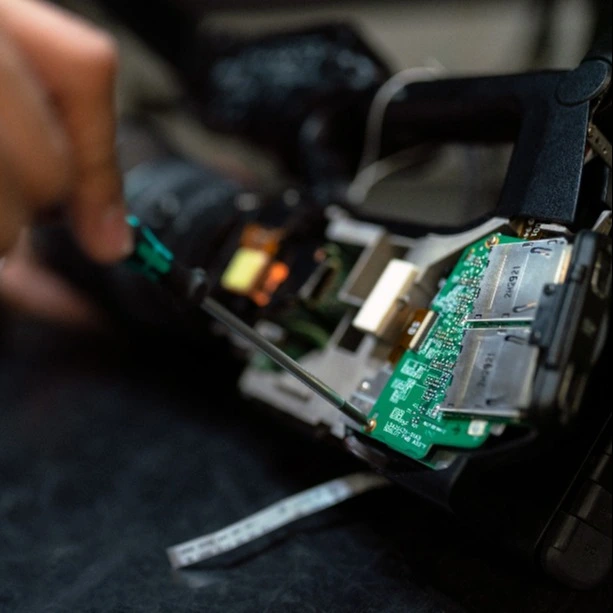
The algorithm commonly used to calculate the AoA is called MUSIC (MUltiple SIgnal Classification). Computationally, this is an intensive procedure—it is not feasible to implement MUSIC on the asset tag or locator. This requires each locator to backhaul samples for processing to either an 'edge processor' or the cloud. Given the quantity of data, the preferred way to do this is via cabled ethernet connections, which increases both locator cost and installation complexity. Phase Ranging tags, on the other hand, calculate their own location. They do not need an extensive backhaul infrastructure. Through the use of a Low Power Wide Area Network (LPWAN) link for backhaul means that no cables are required. -
Multipath
Anyone who deals with indoor asset tracking knows that metallic objects can reflect signals. Much of the work done at Link Labs with Phase Ranging systems has been to minimize the impact of reflection. In this case, AoA is not really comparable. Since ranging measures signal arrival time, it naturally discriminates multipath. In an angle-based system, multipath is harder to identify. Although the MUSIC algorithm can help discriminate the multipath, it has a significant weakness: the algorithm assumes that any received signals are uncorrelated (in other words, the signal does not come from the same source). However, multipath reflections are highly correlated since they are delayed versions of the same signal. This necessitates the use of supplementary information, such as signal strength, to calculate a rough distance to the tag, but signal strength-based range measurements are notoriously inaccurate, especially at further distances from the locator. -
Accuracy
Accuracy is arguably the most important metric of an RTLS, yet also the most nuanced. As an example, here's a Cumulative Distribution Function (CDF) of location accuracy from a warehouse using Link Lab’s OnSite XLE® Phase Ranging system.
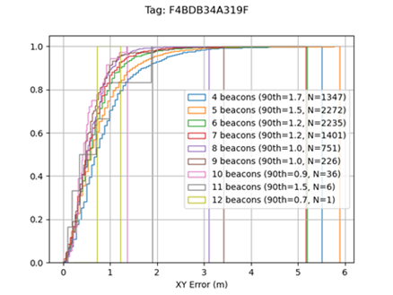
Y-axis represents percentiles--e.g. 0.5 = 50%--and the X-axis represents a parameter – in this case, system accuracy in meters
To provide realistic expectations, we specify the 90th percentile accuracy (meaning the accuracy that was achieved 90% of the time; these are the stats specified in the plot legend along with the number of beacons used in the fix)—in this example, it's around 1.2 meters. However, if we instead used the 50th percentile as our spec, we could say it has an accuracy of 40cm. When comparing system accuracy specifications, it is crucial that the underlying methodology is the same, otherwise it’s not a fair comparison. After all, looking at the above plot, notice that some percentage of the time millimeter accuracy was achieved. Less scrupulous system vendors may choose to use lower percentile numbers to make their system appear more accurate than it is—so always ask under what conditions the accuracy was measured, and what statistical benchmarks were used.
Phase Ranging through AirFinder OnSite XLE®
Understanding the differences between Phase Ranging and AoA is vital when making a decision on which asset tracking solution to implement. That said, Phase Ranging is generally regarded as the better overall technology. At Link Labs, our AirFinder Onsite Xtreme Low Energy (XLE®) uses Phase Ranging technology to provide users accuracy without compromising on tag battery life and cost. For more information on XLE®, book a demo today.